Resources and Development
Resources and Development – Chapter 1 Class 10 Geography (NCERT)
Resources and Development is Chapter 1 of Class 10 Geography (Contemporary India – II). It explains the meaning, types, and importance of resources, along with the need for resource planning and sustainable development. The chapter also covers land resources, land use patterns, soil types, land degradation, and conservation methods. Below are complete notes of Resources and Development aligned with NCERT, RBSE and CBSE board exam patterns.
Resources
Everything in our environment that can be used to fulfil human needs is called a resource. For anything to be considered a resource, it must be technologically accessible (we have the technology and skills to use it), economically feasible (its use is affordable and cost-effective), and culturally acceptable (its usage is approved and accepted by society).
Interdependent Relationship between nature, technology and institutions
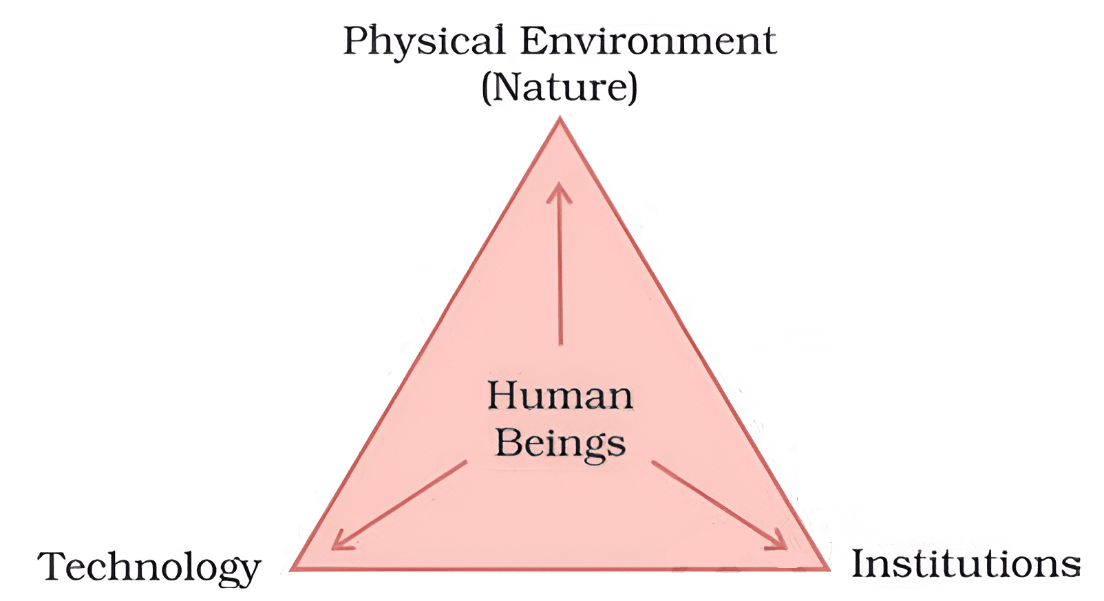
The process of turning things in our environment into useful resources involves a connection between nature, technology, and institutions. Humans use technology to interact with nature, while institutions guide how resources are used and managed to ensure faster economic growth.
Are resources free gifts of nature?
Many people think that resources are free gifts of nature, but that is not true. “Resources are function of human activities”. It means human take the materials available in nature and transform them into useful resources using their knowledge, skills and technology. So, humans are the most valuable resource because they make all other resources useful.
Classification of Resources
- On the basis of origin: Biotic and Abiotic.
- One the basis of exhaustibility: Renewable and non-renewable.
- On the basis of ownership: Individual, community, national and international.
- On the basis of status of development: Potential, developed resources, stock and reserves.
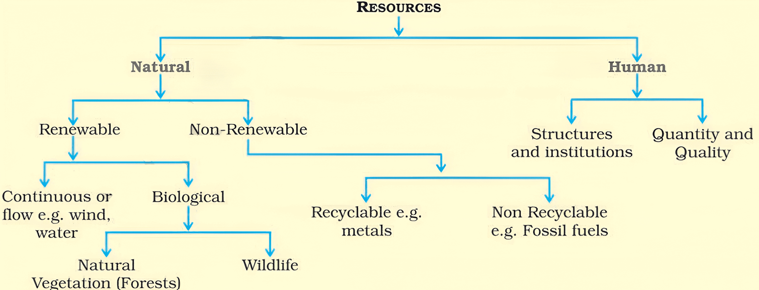
Note: Human resources are not just people, but people who are trained, educated, and healthy.
Their development depends on the structures and institutions, and their strength depends on their quantity and quality.
Development of Resources
Need for Development of Resources
Resources are essential for human survival and to maintain a good quality life. But earlier people thought resources were just free gifts of nature. Due to this belief, resources were consumed without proper planning or control. It causes following problems:
- Resource Depletion: A few people used too many resources to satisfy their own greed, resulting in depletion in resources.
- Unequal Distribution: Resources are collected in the hand of a few rich people or countries, which lead to social inequality. It makes two groups: haves (rich) and have nots (poor).
- Environmental Crisis: Overuse of resources causes many environmental issues, such as global warming, ozone layer depletion, pollution and land degradation.
Therefore, proper development and resource planning are essential for sustaining the quality of life and global peace. Otherwise, the future of our planet will be in danger.
Sustainable Development
Sustainable economic development means development should take place without damaging the environment, and development in the present should not compromise with the needs of the future generations. It involves:
- Judicious use of resources
- Environmental protection
- Social and economic equality
- Long term planning
Rio de Janeiro Earth Summit, 1992
- In June 1992, more than 100 head of states met at Rio de Janeiro (Brazil) for the first International Earth Summit.
- Aim: Environmental protection, socio-economic development, and promotion of sustainable development worldwide.
- Key Outcome:
- Signed the Declaration on Global Climatic Change and Biological Diversity.
- Endorsed the Global Forest Principles.
- Adopted Agenda 21 – a global plan of action for sustainable development in the 21st century.
Agenda 21
- Agenda 21 is a declaration signed by a world leader in 1992 at the UNCED – United Nations Conference on Environment and Development, held in Rio de Janeiro, Brazil.
- It is a comprehensive action plan to achieve sustainable development globally, nationally, and locally.
- Aims of Agenda 21:
- Protection of the environment.
- Elimination of poverty.
- Control of diseases and health-related issues.
- Equal cooperation among countries on common interests, mutual needs, and shared responsibilities.
- Every government should prepare its own local Agenda 21 to promote planning at the local level for sustainable development.
Resource Planning
Resource Planning is a strategy for the proper and judicious use of resources to ensure their balanced distribution, sustainable utilization, and availability across all regions. It aims to reduce resource wastage, prevent overuse, and promote equitable development for present and future generations.
Why? (Especially in India)
India has a huge diversity in the availability of resources. Some regions are rich in certain resources, while others face severe shortages. This uneven distribution of resources creates regional imbalances. Therefore, proper resource planning is necessary at the national, state, regional, and local levels to ensure balanced development, reduce inequality, and achieve sustainable growth.
| Regions/State | Rich | Lacking in |
| Jharkhand, Chhattisgarh, MP | Minerals and coal deposits | Lack in water or infrastructure |
| Arunachal Pradesh | Water resources | Infrastructure (Road, power etc.) |
| Rajasthan | Solar and wind energy | Water resources |
| Ladakh | Cultural heritage | Water, infrastructure and vital minerals. |
Resource Planning in India
There are three major steps of resource planning in India:
- Identification and Inventory of Resources – Finding out what resources are available in different regions through surveying, mapping, and quantitative & qualitative estimation.
- Developing a Planning Structure – Creating a system with advanced technology, trained personnel, and proper institutions for effective management and utilization of resources.
- Matching Resource Plans with National Goals – Using resources in a way that promotes balanced regional development, sustainability, and overall economic growth of the nation.
Question: Since when has India made efforts for resource planning?
Answer: Since the First Five Year Plan after Independence.
Question: Name three factors besides resource availability that are essential for development.
Answer: Three factors are:
1. Technology
2. Quality of human resources
3. Historical experience.
Conservation of Resources
Why is Conservation Important?
Resources are the backbone of human development, but overuse or misuse of resources can create serious challenges. It can lead to socio-economic problems like poverty and inequality, as well as environmental problems such as pollution, deforestation, and land degradation. To overcome these issues and ensure sustainability, resource conservation at all levels: local, regional, national and global is essential.
Mahatma Gandhiji’s View on Resources
- “There is enough for everybody’s need, not for anybody’s greed.”
- The root causes of resource depletion at the global level are:
- Greedy and selfish individuals
- Exploitative nature of modern technology
- He was against mass production and advocated for production by the masses.
International Efforts
- 1968 – Club of Rome
First organization to promote systematic resource conservation, highlighting the need for global cooperation in managing resources. - 1974 – E.F. Schumacher
Presented Gandhian philosophy of simple living and sustainable use of resources in his famous book “Small is Beautiful”. - 1987 – Brundtland Report
Introduced the concept of Sustainable Development and promoted it worldwide through the report “Our Common Future”. - 1992 – Earth Summit (Rio de Janeiro)
Turned sustainable development ideas into global agreements and action plans, including Agenda 21.
Land Resources
Land is a vital natural resource as it supports natural vegetation, wildlife, human life, economic activities, transport and communication systems. But land is a finite resource, so it must be used wisely with proper planning.
Relief Features of Land: Refers to the shape, height and type of landforms. India has mountains, plateaus, plains and islands.
- Plains (43%): Suitable for agriculture and industries.
- Mountains (30%): Source of perennial rivers, promote tourism, and support ecological balance.
- Plateaus (27%): Rich in minerals, fossil fuels and forests.
Land Utilization
Land resources are used for the following purposes:
- Forests: Maintaining ecological balance and biodiversity.
- Land not available for cultivation:
- Barren land waste land
- Land put to non-agricultural uses such as buildings, roads, railways, factories.
- Other uncultivated land: (Excluding fallow land)
- Permanent pastures and grazing land
- Land under miscellaneous tree and groves (Not included in the net sown area).
- Culturable waste land: Land uncultivated for more than 5 agricultural years.
- Fallow land: agricultural land that is left uncultivated for a certain period to allow soil to recover.
- Current fallow: Left uncultivated for one or less than one year.
- Other than current fallow: Left uncultivated for the past 1 to 5 years.
- Net Sown Area: Actual land area where crops are sown and harvested once in a year.
- Gross Cropped Area: Net Sown Area + Area sown more than once in a year.
Net Sown Area and Gross Cropped Area
Actual land area where crops are sown and harvested once in a year is known as NSA (Net Sown Area). Net Sown Area plus area sown more than once in a year is known as GCA (Gross Cropped Area). Examples:
- A farmer owns 2 hectares of land.
- Grows wheat in winter.
- Grows rice on the same land in summer.
- NSA = 2 hectares.
- Area sown more than once = 2 hectares.
- GCA = NSA + Area sown more than once = 2+2 = 4 hectares.
Land Use Pattern in India
Land Degradation and Conservation Measures
Land supports 95% of our needs (food, clothing, shelter). Land degradation is the decline in the quality and productivity of land due to natural processes or human activities.
Main Causes of Land Degradation
- Deforestation: Large scale removal of trees from forests for human activities. It promotes soil erosion, which removes the topsoil and causes land to degrade.
- Overgrazing: Too much grazing by animals that damages the land.
- Mining and Quarrying: Mining is the process of extracting minerals from deep underground. Quarrying is the process of extracting stones, sand or minerals from the surface. Both left deeps pits and damaged land.
- Over Irrigation: Excessive watering of land causing waterlogging, salinity and soil degradation.
- Mineral Processing: Grinding of minerals generate huge quantity of dust in the atmosphere. It prevents water from going into the soil.
- Industrial Waste and Pollution: Industrial effluents is main source of land and water pollution.
State Wise Examples of Land Degradation Along with Cause
- Jharkhand, Chhattisgarh, MP, Odisha: Deforestation due to mining.
- Gujarat, Rajasthan, MP, Maharashtra: Overgrazing.
- Punjab, Haryana, Western UP: Over irrigation causing waterlogging, salinity and soil degradation.
Majors of Land Conservation
- Afforestation: Plant more trees on deforested land.
- Proper Grazing: Avoid overgrazing.
- Shelter Belts: Plant trees in rows to stop strong winds.
- Sand Dune Controls: Grow thorny plants to hold the sand.
- Manage Waste Land: Improve and reuse damaged land.
- Control Mining Activities: Avoid leaving mining sites open.
- Proper Waste Disposal: Treat industrial waste before releasing it.
Soil As a Resources
- Soil is the most important renewable natural resource.
- It acts as the medium for plant growth and supports a wide variety of living organisms on Earth.
- Soil is often called a living system because it contains microorganisms and organic matter essential for life.
- Soil formation is an extremely slow natural process – it takes millions of years to develop just a few centimeters of soil.
Soil Formation
The process of soil formation, also known as Pedogenesis. is very slow and takes thousands to millions of years. Steps in Soil Formations are:
- Weathering of Rocks – Rocks break down into smaller particles due to wind, water, temperature changes, and natural chemical reactions.
- Organic Matter Addition – Dead plants and animals decompose and form humus, which mixes with mineral particles to increase fertility.
- Soil Horizons Development – Over time, different layers of soil (topsoil, subsoil, bedrock) are formed, each with distinct properties.
- Chemical & Biological Changes – Microorganisms, roots, and natural chemical reactions enrich the soil with essential nutrients.
- Soil Composition: A balanced mix of inorganic minerals (sand, silt, clay) and organic matter (humus) makes soil suitable for plant growth.
Factors Affecting Soil Formation
- Relief (Landforms): Determines drainage, slope, and erosion.
- Parent Rock: Provides the basic mineral content of the soil.
- Climate: Rainfall, temperature, and wind affect weathering and humus formation.
- Vegetation & Organisms: Roots, plants, microbes, and animals contribute to humus and soil mixing.
- Time: Soil formation is extremely slow, taking centuries to form just a few centimeters.
Soil Profile
A soil profile is a vertical cross-section of the soil that shows its different layers, also called soil horizons. Each horizon has distinct characteristics in terms of composition, texture, and fertility.
- O-Horizon (Organic Layer):
- The topmost layer, made up of organic matter like decomposed leaves and plants.
- Rich in humus, improves soil fertility.
- A-Horizon (Topsoil):
- Also called topsoil, it is dark in color and rich in humus and minerals.
- Supports most plant and microbial life, ideal for agriculture.
- B-Horizon (Subsoil):
- Found below the topsoil, it contains more minerals but less organic matter.
- Usually lighter in color and harder than A-Horizon.
- C-Horizon (Substratum):
- Made of partially weathered parent rock.
- Almost no humus, but important for supplying minerals to upper layers.
- R-Horizon (Bedrock):
- The deepest layer consisting of Un-weathered parent rock.
- Very hard and does not support plant growth directly.
Classification of Soil
On the basis of factors responsible for soil formatin, colour, thickness, texture, age, chiemical and physical properties, types of soil are:
- Alluvial Soils
- Blck Soils
- Red and Yellow Soils
- Laterite Soils
- Arid Soils
- Forest Soils
Alluvial Soils
Alluvial soil is the most widely spread and important soil type in India. It covers vast fertile regions and supports intensive agriculture.
- Distribution: Found in the entire Northen Plains.
- A narrow corridor in Rajasthan and parts of Gujrat.
- Eastern Coastal Plains, especially in the deltas of Mahanadi, Godavari, Krishna and Kaveri.
- Formation: Deposited mainly by the three great Himalayan rivers: Indus, Ganga and Brahmaputra.
- Texture: A balanced mixture of sand, silt, and clay.
- Grain Size Variation: Coarse in upper river valleys and piedmont plains (Duars, Chos, Terai). Fine in the lower river plains.
- Types by Age:
- Bangar: Old Alluvial, less fertile, contains a high concentration of kankar (calcareous deposits).
- Khadar: New Alluvial, more fertile, renewed every year by floods, less kankar.
- Fertility: Highly fertile, hence densely populated regions with intensive cultivation.
- Nutrient Content: Rich in potash, phosphoric acid and lime.
- Crops Grown: Sugarcane, Paddy, Wheat, Cereals, Pulses.
- Other Features: In drier regions, alluvial soil is more alkaline, but with proper irrigation and treatment it becomes highly productive.
Black Soil
Black soil, also known as Regur Soil or Black Cotton Soil. It is highly fertile and ideal for cotton cultivation.
- Color: Characteristic black color due to the presence of iron compounds.
- Crop grown: Cotton.
- Formation Factors: Black soil was formed from the slow breakdown of dark colored basalt volcanic rocks under the influence of climate.
- Distribution: Found mainly in the Deccan Trap (basalt) region, including Maharashtra, Saurashtra, Malwa, MP, Chhattisgarh, Godavari and Krishna Valleys.
- Texture: Made up of very fine clay material and has excellent moisture retaining capacity.
- Nutrient Content: Rich in Calcium carbonate, Magnesium, Lime and Potash. Soil is poor in Phosphoric content.
- Other Features: Black soil develops deep cracks in summer, allowing better aeration of the soil. During the rainy season, it becomes sticky.
- Develops deep cracks during summer, which improves aeration. Becomes sticky when wet, making it difficult to plough. So, farmers plough it after the first shower.
Red and Yellow Soils
- Color: Red (Due to diffusion of Iron in crystalline form and formation of Iron oxide). Yellow (Hydrated form of Iron oxide).
- Formation: Form of crystalline igneous rocks under low rainfall in Deccan Plateau (East and south).
- Distribution: Found in Odisha, Chhattisgarh, Southern parts of Ganga Plain and Piedmont zone of Western Ghats.
- Texture: Sandy to loamy and porous in nature.
- Fertility: Less fertile compared to alluvial and black soils.
- Crops: Suitable for pulses, millets, and oilseeds.
Laterite Soil
Laterite soil is a type of soil found mainly in tropical and subtropical regions. The name “Laterite” comes from the Latin word Later, meaning brick. It becomes very hard like a brick when dry.
- Formation: It is formed by intense leaching in tropical and subtropical regions. Heavy rainfall and alternating wet and dry seasons remove nutrient from the soil.
- Texture: Porous and Clayey.
- Color: Reddish-brown.
- pH: Acidic in nature (pH<6).
- Nutrient Content: Deficient in plant nutrients. Rich humus content in deciduous and evergreen forest regions. Poor humus under less planted region.
- Distribution: Mostly in southern states (Kerala, Tamil Nadu, Karnataka, Andhra Pradesh), Western ghats region of Maharashtra, Odisha, some parts of West Bengal and North-east region.
- Crops: Tea, Coffee, Cashew nuts.
- Other Features: High risk of erosion and degradation due to position (Slopes).
Arid Soil
Arid soils are typically found in dry regions with high temperatures and very low rainfall. They are sandy, saline in nature, and lack sufficient humus and moisture, which makes them less fertile. However, with proper irrigation, they can be made cultivable.
- Color: Reddish to brown.
- Texture: Sandy in nature.
- Nature: Saline due to evaporation of water, poor in humus and moisture.
- Climatic Conditions: Found in areas with dry climatic, high temperature, and low rainfall.
- Fertility: Naturally less fertile but can support crops with irrigation.
- Distribution: Common in Rajasthan and other arid regions of India.
- Other Features: Presence of Kankar (Calcium carbonate) layer in lower horizons, which blocks water infiltration and causes hardness in the subsoil.
Forest Soil
- Distribution: Hily and mountainous areas (Himalayas, North-east, Western Ghats).
- Texture: loamy and silty in valleys and coarse-grained on upper slopes.
- Nature: Acidic, low humus (Due to rain fall and cold climates).
Soil Erosion and Soil Conservation
Soil erosion is the removal or washing away of the topsoil layer by natural forces like water, wind or human activities. Soil erosion always occurs, but it is usually balanced by soil formation. The soil formation becomes a problem starts when erosion happens faster than new soil can form.
Cause of Soil Erosion
- Natural Causes of Soil Erosion: Wind, glacier and water.
- Human Activities: Deforestation, overgrazing, construction and mining and wrong farming practice (Ploughing up and down the slope).
Types of Soil Erosion
- Gully Erosion: Running water can cut through clayey soil. This creates deep narrow channels in the land, called gullies. The land becomes uneven and unfit for farming. Such damaged land is called bad land.
- Sheet Erosion: Sheet Erosion is a type of soil erosion where a thin layer of topsoil is washed away over a large area by flowing rainwater.
- Wind Erosion: Type of soil erosion where loose, dry topsoil is blown away by strong winds.
- Rill Erosion: Erosion caused by defective farming methods, such as ploughing up and down, forms small channels in soil. It is called rill erosion and such channels is known as rills.
Methods of Soil Conservation
- Contour Ploughing: Ploughing the land along the contour lines (not up and down). It slows down the flow of water. It prevents the topsoil from erosion by water.
- Terrace Farming: Steps are cut into slopes or hillsides to create flat areas for farming. It reduce water runoff and prevent soil erosion by water. It is common in the Western and Central Himalayas.
- Strip Cropping: Dividing large fields into strips and planting grass between crops. The grass strips reduce wind speed and preven soil erosion by wind.
- Shelter Belts: Rows of trees or shrubs are planted in lines to create wind barriers (shelters). They reduce the wind speed and prevent soil erosion. Very effective in desert regions like western Inida to stabilize sand dunes.
Resources and Development – Practice Questions
Question: What type of soil is found in the river deltas of the eastern coast? Give three main features of this type of soil.
Answer: Alluvial Soils. Three features are:
- High Fertility (Have potash, phosphoric acid and lime).
- Soil contains sand, silt and clay.
- Formed by three Himalayan River Indus, Ganga and Brahmaputra.
Question: Name three states having black soil and the crop which is mainly grown in it.
Answer: Maharashtra, Madhya Pradesh and Chhattisgarh. Main grown crop is Cotton.
Question: How do wrong farming methods lead to soil erosion?
Answer: Wrong farming methods, such as ploughing up and down the slope, lead to soil erosion. They create channels in the soil. Rainwater flows quickly through these channels. It washes away the nutrient rich top layer of soil.
Question: What are ravines?
Answer: Running water can cut through clayey soil. This creates deep narrow channels in the land, called gullies. The land becomes uneven and unfit for farming. Such damaged land is called bad land. In the Chambal basin such band lands are called ravines.
Resources and Development – RBSE PYQ
- Examine “Small is Beautiful” book.
- Identify the chemical characteristics and components of Alluvial soil.
- Area sown more than once in agriculture year:
- Gross cropped area 3. Net sown area
- Fallow lands 4. Pastures.
- Which of the following is non-recyclable resources:
- Water 3. Fossil Fuel
- Natural Vegetation 4. Wildlife
- Describe the process of soil formation.
- Briefly explain black soil.
- If you have to do resource planning, which steps would you use?
- Classify the resources on the basis of exhaustibility.
- What is soil-erosion? Write the reasons of soil erosion and methods of soil-conservation.
- Write two measures for conservation of land degradation.
- Write the names of any two non-renewable resources.
- Write names of any four types of soils found in India.
- What do you understand by systainable development?
- Explain two problems caused due to the indiscriminate use of resources by humans.
- Suggest two methods to conserve soil.
- Write any two features of Arid soil.
- Defien resources? Write its types on the basis of origin.
Resources and Development – CBSE PYQ
Explore Our Quality Contents
All Class 10 Social Science Chapters
All Class 10 Science Chapters
Suggest Links
NCERT Official Text Books
Rajasthan Board Official Site
CBSE Official Site